
Geography (Geographic Information Systems)
Are you interested in learning a set of skills that will make you employable in a wide variety of industries? Would you like to have a job that could allow you to work both in and outdoors? How about a career where you use technology and maps to explore spatial relationships on Earth? Then Geographic Information Systems (GIS) may be for you.
GIS is a computer-based mapping system that allows you to query, analyze, and interpret relationships, trends, and data in the world in which we live.
What are the features of Casper’s program?
Examples of student projects:
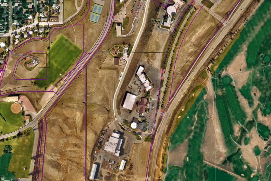
Creating an Online Map For Casper College
Students in the Advanced GIS Class collected data from around campus using GPS and Drones. The data was compiled into an online map for everyone on campus to view and use.
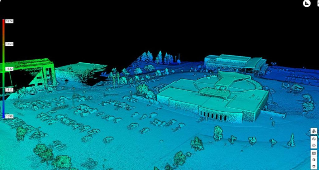
Using Advanced LiDAR Data to Model The Casper College Campus
The Natrona County Chapter of The Society for Mining, Metallurgy, and Exploration (SME) made a donation to purchase The Zenmuse L1 LiDAR camera. LiDAR stands for Light Detection and Ranging and uses active pulses to detect the elevation of objects on the surface of the Earth. Students used the LiDAR camera along with the new Matrice 300 drone to model Casper College in 3D using the LiDAR data.
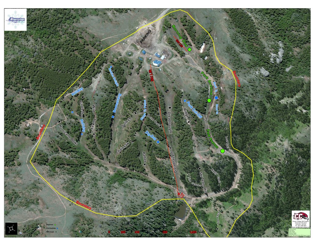
Creating an Aerial GIS Map For Hogadon Ski Area
Casper College GIS Students were contacted by The CIty of Casper to create an aerial photo map of the Hogadon Ski Area. The map is being used by the city and also by Hogadon employees.
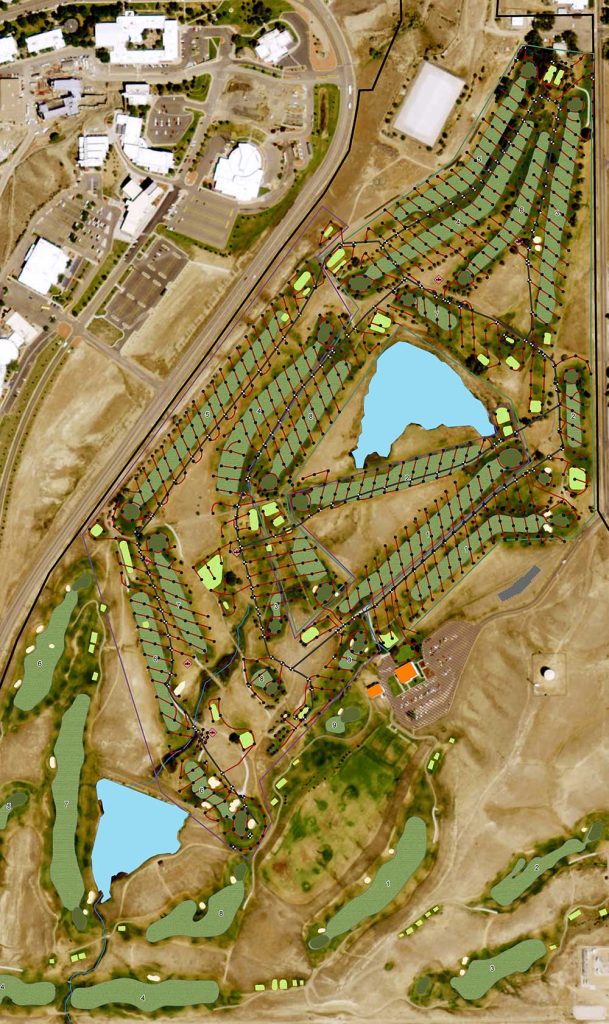
Mapping Irrigation Infrastructure for The Casper Municipal Golf Course
The city of Casper asked the GIS Program to collect all of the new irrigation infrastructure that was installed at The Casper Municipal Golf Course All of the points that represent the sprinklers, and the lines that represent water lines, were collected using GPS units and imported into maps for the city of Casper.
What can I do with this major?
Employment info
Learn more about jobs and wages by reviewing the general employment profile for geographic information systems technicians in Wyoming and across the U.S.
Places where students have worked:
- Natrona County GIS Dept.
- City of Longmont, CO, GIS Dept.
- DigitalGlobe – Longmont, CO
- Education Logistics, Missoula, MT
- Natrona County Health Dept.
- Cameco
- Linc Energy
- Goolsby, Finley Associates in Casper, WY
- Barlow and Haun Inc. in Casper, WY
- 609 Consulting LLC in Casper and Sheridan, WY

“The GIS program at Casper College helped me gain a thorough knowledge of ArcGIS, its products, and other related programs that interact with GIS. After graduation from Casper College, I was able to use my knowledge to expand into the spatial world of public infrastructure, engineering design support, and becoming a first responder for emergency operations. Without the talented and knowledgeable staff at Casper College, I wouldn’t be as successful as I am today.”
— Brett Rosso, Senior GIS Mapping Technician, City of Longmont Colorado

What are the special admission requirements, if any?
There are no prerequisites for this program.
What courses would I take?
For requirements and more information about this program, view its listings in the academic catalog:
Interested in online learning?
A portion of the courses in this program may be available online. Learn more about online programs and courses at Casper College.